


Einführung/Introduction Mauritius
Die Republik Mauritius liegt im Indischen Ozean, etwa 2400 Kilometer von der Küste Ostafrikas entfernt. Sie ist 67 Kilometer lang und misst an der breitesten Stelle der Ost-West-Ausrichtung 46 Kilometer. Mauritius ist aus einem Vulkan entstanden und umfasst 2.040 km². Verstärkte Tropenstürme sind Zeichen des Klimawandels.
The Republic of Mauritius is situated in the south west Indian Ocean, approximately 2,400 km from the south east coast of Africa, located just to the north of the Tropic of Capricorn. The island is only 67 km in length and 46 km at its widest point, with a total land area of 2,040 km², owing its origins to submarine volcanic activity. Although the volcanoes are long since dormant, they have left their mark on the profile and landscape of the island. As a political entity, the Republic includes not only the island of Mauritius but also the tiny island of Rodrigues some 563 km to the east, as well as the Cargados Carajos Archipelago (St. Brandon) and the two virtually uninhabited Agalega islands, 400 km to the north east and 1,000 km to the north of Mauritius respectively.
Source: http://www.sadc.int/member-states/mauritius/
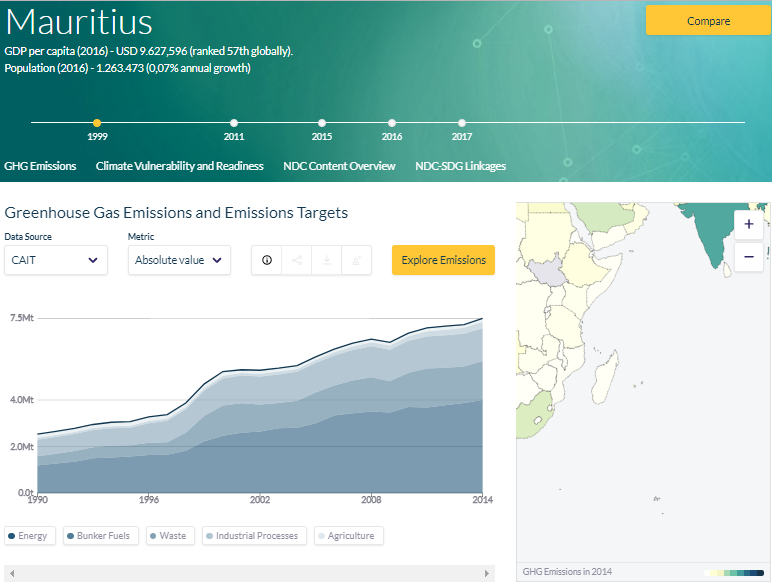
Climate Watch Data / Klimadaten: Mauritius
Source: SDG Linkages Northrop, E., H. Biru, S. Lima, M. Bouye, and R. Song. 2016. “Examining the Alignment Between the Intended Nationally Determined Contributions and Sustainable Development Goals.” Working Paper. Washington, DC: World Resources Institute. Available online at: www.climatewatchdata.org